I’ve been flying around the world in my T-7 and it’s been fun so far. I’ve covered the coasts of Europe, Africa and the southern Arabian peninsula. Once I got to Pakistan I decided to follow the mountains across Asia. I’m not sure what I’ll do once I get to the Pacific coast. Now that I’m deeply in the Himalayas the airports become a little more challenging. I’ve crashed at a couple – Jumla and Lukla. I’ve crashed mostly because of high descent rates but also because of running out of runway. The little T7 doesn’t have reverse thrust and I’m gradually learning the limit of the braking.
Crashed At Jumla
This map shows the route I flew to get from Simikot to Jumla and the fact that my aircraft is pointing the wrong way is not because I’ve started to taxi but more due to the fact that the plane was tumbling along the runway after an “aggressive” approach.
Jumla Approach
If you expand the image you can see where the runway is and I know it looks fine but I didn’t manage it the first time. I did ok on the second attempt which is not really what you want a pilot to be especially good at!
This is comms#1978 and so here are some things that happened in that year of our lord [what a load of crap].
The first GPS Satellite is launched.
Jimmy Carter proposes cancelling neutron bomb development.
Hitchhikers Guide to the Galaxy is first broadcast.
I’ve spent a fair amount of time recently flying around the world, in a flight simulator. Let’s make that clear, I’m playing a game on a computer. I’m not doing this in real life. This started as a coastline tour of the UK from RAF Valley heading south and I just got stuck following coasts all the way to Pakistan. One day there will be a list on this site of all the airports I’ve landed at, well, at least since I’ve been keeping a list, which I think starts in Africa.
I’m going to skip the coastline of India and head across the Himalayas to see some mountainous scenery. I’m not sure where I’ll go once I hat the coast again, and I’m not sure when I’ll head back to the UK. Maybe I’ll just do a trip around the eastern hemisphere for now? I don’t know.
The Coast Of Hingol National Park
While I’ve been flying I’ve been learning more about operating the aircraft and trying flight plans etc. I think I’ve just about managed to program a plan into the flight computer, but I haven’t yet followed it because I keep seeing valleys to get low down in.
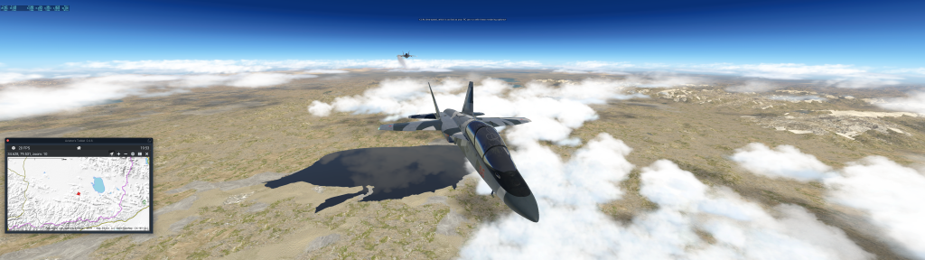
China India Border With A Friend In Tow
I had been using some software to add other players into my game, but no one is really around where I am so I’ve been using the PC to generate other planes. This picture shows another T7 following me. I was worried it was going to shoot me down as I have combat turned on, but they just kept their distance and left me alone. It was quite nice to have someone else in the sky, even if it’s just an “AI” plane.
Just Over Surigh Yilganing Kol
So, I#ve recently landed at Leh, in India and I think it’s the first landing I’ve made in India. I’m not sure. The borders around here are a little hazy! Looking at Google maps I’ve just missed K2 and I won’t be going back for it. I’ve got to keep on moving eastwards.
This is comms#1971, so here are some things that happened in that year:
I’m not sure when I started this journey but I’ve been flying [in a Sim – X-Plane] around the coastline of the world. I started on Anglesey in Wales and am currently in Iran. I suspect a future communication will just be a big long list of the airports visited as I complete this journey. I nearly turned around once I reached the Red Sea but have decided to see what happens as I head further east.
Dayrestan to Jask Military. X-Plane. #roundtheworldtrippic.twitter.com/sfzrxm1xm1
As I pass through airports I’ve been tweeting my journey. I’m not sure when I started doing that, I think I just wanted a record of the flights somewhere. They are in my virtual log book and also on a scrap of paper on the table next to me. The first one on the paper is Bamenda. I completed that flight on 13 July.
Landing at Bamenda, Cameroon. Part of the round the world tour in twenty minute steps. Started at RAF Valley, Wales have mostly followed coastlines. pic.twitter.com/HZ2nH0zYlV
I’m not sure in what format to have all the airports listed in the end. Watch this space and see what I say. If you are lucky and go to this MAP when I am flying then you’ll be able to see where I am and what I’m doing. My aircraft user name is Kertz. Click on the aircraft to see which one is mine. You might be told it’s a Cessna. I can assure you it isn’t. Because the JoinFS software I used works across platforms you have to tell it what you are flying. There are some categories, but over all I have found that the system works well and I’ve flown with a friend while they are based in Texas IRL.
You Can Track My Flights
Above is what the maps will look like if you can find me. When you click on the aircraft there is information about them that pops up. It’s quite a neat little trick.
This is communication 1959 and here are some things that happened in that year:
Alaska becomes the 49th USA state.
A referendum is Switzerland turns down women’s suffrage.
British Empire Day is renamed Commonwealth Day. Why do we still have MBE medals??
I think I’m going to stop. I’ve bought a beast of a machine with screens to match those abilities. I remember I first bought a PC for making music and I wasn’t really bothered about gaming performance, and that’s still mostly true. I’m not a hardcore PC gamer but I am very interested in flying. It just happens to turn out that the flight sim of choice – X-Plane is quite consuming of PC power. It’s also an odd program with the way it utilises the cores of the PC. Anyway. I’ve been trying to get the best flight simulation screen-age. I think I’m there although to use all the pixels to the maximum I will need another PC but that’s going to have to wait.
The Beautiful Front View
I’m not going to go through the specification of everything. Needless to say I’m very happy with it all. The curved monitor is very bright! It also chucks out a lot of heat so I think I’m not doing my bit for the environment. To keep everything in this position there’s a level of chaos to the reverse view:
Takes To Have Beauty
The curved screen has its own stand and the two top monitors are connected via 100mm VESA things to different arms on the metre high pole screwed to the desk. Look, it all works fine and is lined up to within tolerances.
This is communication 1953 and so here are some things that happened in that year of the common era in keeping with recent tradition:
Derek Bentley is executed [murdered by the state] in Wandsworth prison.
The North Sea flood kills over 2000 in coastal countries.
I can’t remember how long I’ve been flying around the world in X-Plane. I know I started at RAF Valley in North Wales and I’m now in Oman. I almost decided to quit and head back to the UK just to see something other than desert. Maybe the views will get more interesting once I hit the Indian subcontinent? I’ve tried the terrain following radar and that seems to work quite well, I do suspect that at times the system gets into a System Induced Oscillation and I have to keep an eye on that while chucking it along at 600 knots and 200 feet. I could set the thing to go lower but I don’t know what the lead time is when heading into the hills.
I’ve been using both screens as a wide screen monitor and I’m impressed with the results. I’m getting 50FPS in the desert and at altitude which is good. Then, when over simple towns it doesn’t change much but over Kent the frame rate drops to around 24 which, if I’m being honest, is fine as far as I’m concerned. There are some strange ways that X-Plane behaves and the limit isn’t the graphics card it’s more likely the fact that the simulator only uses one core in the CPU.
I flew over the Alps from Saanan to somewhere close to Italy and on the way I popped up over the Matterhorn. This was me testing the new set up and frame rates in a complex, but basic in terms of human infrastructure, area of the world. I wanted to see how smooth the flight simulator felt and I will say that it worked perfectly. I could increase the framerate a little more if I used a different aircraft but why would anyone want to do that?
The Matterhorn, because it’s there
It’s not so easy to get the external pictures when using a widescreen set up but I think I managed it well. Not sure if I can get the widescreen look with an in-program snap shot but I could keep trying. I’m not sure if it would look good as a picture though.
Bombing Run – Oman
While heading over the desert in Oman I tried to get some shots of my bombs firing and I think I did well. I’m lucky that none of the detritus flying around destroyed my aircraft! That has happened many times when I’ve been flying too low and drop bombs in the past. I release the bombs and then the aircraft blows up and the world is suddenly quiet as the game ejects me from my fighter. Oh well!
Today, as I write this, it is the last day of August and I was hopeful that I would beat my previous communications per month total but this month is going to come in second as the most I’ve ever published is 68 in May 2013. There is very little chance of me beating that at any time in the future. It’s too much and I think I’ve become more snobby about the “content” on here and trying to increase the quality of the subjects that I write about. I doubt the actual words I write have improved, but then while learning a lot about language recently I do know that grammar and meanings are very fluid and maybe we shouldn’t shit on people so much for not being able to write good.
This is communication number 1944 and so here are some things that happened in that year of the common era:
521 choke to death after a train stalls in a tunnel in Italy.
The prohibition on married women working as teachers is lifted in the UK.
I recently spent some time at RAF Syerston and saw plenty of flight simulators there and generally the fashion was that you can’t have too many screens. So, because I’ve had a spare screen sitting on the dining room table for the last eighteen months I decided to fit it, again, to the PC. The only place it can go is at “the top” although I’d be tempted to place it into an aircraft instruments position at some point. I had all the gear because I had already tried the monitor there, but didn’t like the look of it. I’ve probably changed my mind for now.
The Flight Simulator System
So, this screen shows the flight simulator running with aircraft view on the right and various instrument views on the other screens. I’m not entirely sure I like this set up and I will try another way of doing this.
Have changed to have the cockpit view spread across the two centre screens, ancillary instruments at the top and a tablet with flight information on it under the main screens. This set up makes more sense as far as I’m concerned. I know the items on the upper screen wouldn’t be there in a real cockpit but I don’t have the kit to move the monitor. It would take too much hassle to make it look proper and I don’t use the PC as a flight sim all the time anyway.
Current Flight Sim Set Up
I’m not necessarily happy about the bezels in the middle of the cockpit view and I know I could adjust the offset to make it look slightly more realistic, but then I would also lose some of the centre instrumentation. I guess the only answer is a massive curved screen. Maybe I’ll get one sometime in the future but I am massively aware that my hot water boiler is fucked and I need to think sensibly about spending money for the next while!!
This is communication number 1942 and so here are a few [non WWII] things that happened that year:
The Sikorsky R-4 first flies
A coal dust explosion in china claims 1549 lives.
The first nuclear accident occurs in Leipzig.
Plutonium is isolated.
The first man-made self sustaining nuclear chain reaction at Stagg Field in Chicago.
In a kind of desperation to be somewhere (anywhere) else along with missing all things aviation based I volunteered to spend some time in Lincolnshire helping staff the RAFAC National Aerospace Camp. This event had been running for about six years and it seemed a good opportunity to use my knowledge and skills along with networking and meeting people of note. There was a large length of time when it was unclear whether this would go ahead or in what form it could run, due to changing Covid-19 restrictions and decisions in the upper echelons of the management structure. In the end it was decided to make this camp non-residential and so cadets would arrive each day from a base, brought by their parents or coaches from Wing. I wasn’t needed all week as a newbie and so I spent just two days at the camp getting to know the people and organisation. It was also a chance to meet old friends, mainly TR, who I last saw at the Shawbury camp two years ago.
RAF College Cranwell
The main crew for the camp seem to stay at PWG but I volunteered to stay ay Cranwell for two reasons. One, I’m not important enough to be with the main crew and Two, I might be able to sneak into CHOM, finally, and stand on the carpet [old traditions]. It’s quite different going to a base when you’ve been on many compared with your first time. I knew my way around and knew where to park along with knowing shortcuts through the mess which is huge.
College Hall Officers’ Mess, RAFC Cranwell
The above picture is not where I was staying, I was in the effective transit mess called Daedalus Officers’ Mess. The above picture shows CHOM and I went in their with the other staff staying at RAF College Cranwell because there is a carpet you may only walk on once you have your commission. When I was first at Cranwell in 2014 I was not permitted near CHOM because there was a passing out parade that day and it was a busy area [it did mean there was a Reds flyover though]. On the Tuesday evening, once we had returned from Syerston, three of us wandered over to CHOM and were allowed to have a look around and get photographs of us on the carpet. The porter was very helpful and lovely.
CHOM, RAFC Cranwell
So, I finally feel official. I’ve stood on the carpet and been in CHOM. I’ve completed my OIC, albeit somewhat delayed. I feel happy that I managed to do my OIC in person as recently staff have been doing them virtually and so won’t get the chance to stay in Daedalus or visit CHOM until they are fortunate enough to be staying close by on some event. It’s quite likely the RAF team I’m in will have a “team building” few days sometime to have a wander around the noisy places in Lincolnshire.
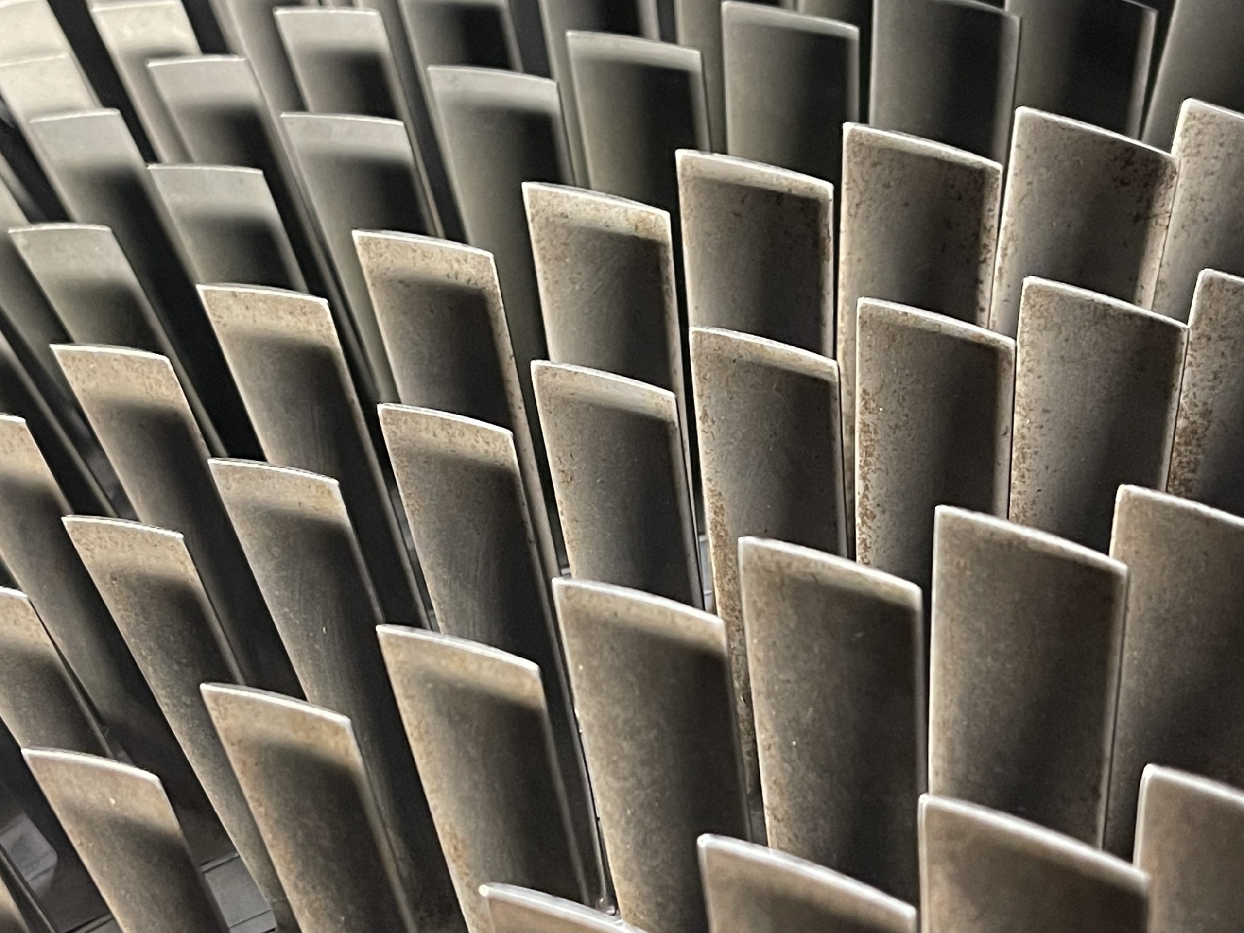
The Tuesday for me was mostly seeing how the camp worked along with a brief chat with the Camp Comm. I saw a talk with Serco where they show us various gliders and engines. I liked the engines, they were cutaway versions so I could see inside. I knew a fair bit of what was going on so I didn’t pay a huge amount of attention to the talk although I did chat with the engineer after the cadets and had some parts of the turbines explained.
RR Avon Compressor Blades
Inside this hanger were loads of gliders and it looked as though they were the original stock from my days in the corps so I looked up my gliding log on this site. I was trying to spot an airframe that I had flown in and while walking along the line of “those yet to be maintained” I spotted one.
ZE585
From this communication you can see that I’ve flown in 585 three times for around 28 minutes total. Not bad really. I do keep checking this site whenever I see an aircraft type that I know I’ve been in to see if it’s one of “mine”. Once outside we had a talk from a current glider pilot who also flew Tornados and he showed us around the two Tornados and the Tucano that were sitting on the pan.
Panavia Tornado GR4, RAF Syerston
I prefer the GR type of Tornado rather than the F type but I do have an image of the F type which is a rare one because it’s an F2 but fitted with F3 type engines and so the rear of the plane looks super stupid. But, I guess it worked. Lunch was provided by a field kitchen, and a fantastic job they did too, I was super impressed with the whole set up. In the afternoon I talked to people about PTT and how I can deliver that in my unit.
Wednesday was my final day at the camp, only here for two days if you remember and a chance to chat to people about PTT and also help with the car marshalling as parents were dropping cadets off in the base. It was nice to be involved and chat to new people. The main event for the camp was the Wednesday afternoon where a private airshow was organised and the bigwigs were invited to see what we do. There was an Air Marshall, the ACO Commandant and others. I just hung around with the few people I had go to know while my head slowly burned in the cloudy weather – we can’t wear lids on the airfield and we have to wear uniform so we can’t wear a baseball cap and I forgot my sunscreen.
On the ground was an Apache from Wattisham and a Juno from Shawbury. It was the actual Juno that I had flown in two years ago which was pretty cool. The flying display consisted of the Red Arrows, the Chinook [which also landed], a Spitfire, a Hurricane, the RAF Falcons, and finally the Typhoon.
Red Arrows – Head to Head
I had wondered whether to use my camera a lot and possibly concentrate too much on getting the perfect picture or do I just watch and absorb the atmosphere. I chose to just take the odd picture here and there on my phone. It was a really chilled out atmosphere and a good chance to chat to plenty of people. The Red Arrows performed their “rolling display” because the cloud cover was pretty low. The BBMF aircraft were impressive for their age and the Chinook was very – how the hell do you make it do that? I really wanted to see the Typhoon because – NOISE. I though even the nine jets of the Reds were quiet. Maybe it’s growing up under a flightpath that means not a lot bothers me.
Red Arrows, RAF Syerston
I was on marshalling duties when the Typhoon display took place. So I was an extra 800m away from the display centre and, while slightly disappointed, I still had a good view. I was basically in charge of keeping the parents calm and in the car park as the Typhoon display was delayed slightly by technical issues. When this thing did arrive the noise made me very happy as the first minute or two is at 100 power and full reheat. You know it’s loud when you can’t talk to the person next to you. It was brilliant and well worth driving through the bloody Dartford tunnel to see. I had a really good time at Syerston and made some good contacts. I’m looking forward to returning next year.
Hmmm, this is communication number 1939. So, in keeping with tradition I write a few things that happened in that year, I’m going to avoid the obvious:
30,000 killed in earthquake in Chile.
Borley Rectory is destroyed by fire.
Lina Medina gave birth aged FIVE, I mean, WTF?
A passenger air service starts between USA and UK.
I’ve been playing around with a few things in X-Plane. I’ve tried direct flight routes using the in-flight computer along with saving flights and then recording the replays from “interesting” angles. My round the world trip started at RAF Valley, I’ll try and find a date if I can. Originally I was going to fly the coastline of Great Britain or maybe even the UK but I ended up turning right at Jersey and have been heading around the coast of Europe and then Africa. I’m currently in Namibia but struggling to find airstrips along the coast so I’m inland for a little while.
Ondangwa to Grootfontein in Namibia. Part of the #roundtheworldtrippic.twitter.com/X3NptqHwC3
I’m trying to tweet each journey with a screenshot just for posterity. My hashtag isn’t unique and so when I try to look back I’m going to get photographs of lots of people who are going around the world for real. I guess one aim of this is to see other places and see what the world looks like. Even if this is virtual at the moment maybe one day I’ll find somewhere cool to live when I retire!
Here’s a video of me landing somewhere. I recorded the flight and then managed to replay it while moving the camera around [not a great landing]:
This next video is me flying from Ruacana to Ondangwa in Namibia. I think I start the flight halfway through and then go through different views so you can see the sort of thing I look at while flying [another not great landing]:
This is communication number 1908 and so here are a few things that happened in that year [AD]:
An opera house fire in Pennsylvania kills 170.
The UK acquired the rights to the first major oil discovery in the middle east.
The model T is launched by Ford – who by the way was a fucking massive anti-Semite.
As part of my round the world trip in X-Plane I landed at Omboue Hospital in Gabon. It’s such a quiet airfield that X-Plane has nothing there. Not sure where my next stop will be, I’m considering flying over the top of the DRC as, you know, it’s the DRC and not a healthy place.
My current flight sim plans are wandering around the Earth from airport to airport and just enjoying the views. I’m currently heading down the west coast of Africa and have recently started recording my journey on Twitter. I don’t use Twitter a huge amount at the moment because ultimately no-one cares what I think and I have friends whom I can moan to about things.
Side image shows mountains of the Campo Ma'an Reserve, Cameroon. Then, Bata approach and full stop at Bata, Equatorial Guinea. #roundtheworldtrippic.twitter.com/uy35VUtKTr
Having just clicked on the hashtag I can see that there are many people using the same hashtag but in reality. They are travelling around the world. Well, given the current pandemic, I am not. Also, I don’t have the money and I have other responsibilities at the moment so I don’t think I can. My next trip is to Scotland in February.
X-Plane Control Panel – iOS
This is a screen capture of the X-Plane Control Panel on my iPhone. It looks at the information in X-Plane on the PC and gives me information about my flight. The bottom display is my glideslope approach to an airport, the middle display is a kind of map with weather display and the top is my PFD. I’m quite impressed with the extra information I get and I’ve been using the glideslope when my approach is through clouds. None of those landings have been successful though and I generally fly those routes again or it seems like I’m cheating. One thing that does happen though is once the iPhone is connected it changes the weather from real-world to whatever the settings are on the phone and that’s a frustration, I will look into this to see if I can correct it.