I recently spent some time at RAF Syerston and saw plenty of flight simulators there and generally the fashion was that you can’t have too many screens. So, because I’ve had a spare screen sitting on the dining room table for the last eighteen months I decided to fit it, again, to the PC. The only place it can go is at “the top” although I’d be tempted to place it into an aircraft instruments position at some point. I had all the gear because I had already tried the monitor there, but didn’t like the look of it. I’ve probably changed my mind for now.
The Flight Simulator System
So, this screen shows the flight simulator running with aircraft view on the right and various instrument views on the other screens. I’m not entirely sure I like this set up and I will try another way of doing this.
Have changed to have the cockpit view spread across the two centre screens, ancillary instruments at the top and a tablet with flight information on it under the main screens. This set up makes more sense as far as I’m concerned. I know the items on the upper screen wouldn’t be there in a real cockpit but I don’t have the kit to move the monitor. It would take too much hassle to make it look proper and I don’t use the PC as a flight sim all the time anyway.
Current Flight Sim Set Up
I’m not necessarily happy about the bezels in the middle of the cockpit view and I know I could adjust the offset to make it look slightly more realistic, but then I would also lose some of the centre instrumentation. I guess the only answer is a massive curved screen. Maybe I’ll get one sometime in the future but I am massively aware that my hot water boiler is fucked and I need to think sensibly about spending money for the next while!!
This is communication number 1942 and so here are a few [non WWII] things that happened that year:
The Sikorsky R-4 first flies
A coal dust explosion in china claims 1549 lives.
The first nuclear accident occurs in Leipzig.
Plutonium is isolated.
The first man-made self sustaining nuclear chain reaction at Stagg Field in Chicago.
In a kind of desperation to be somewhere (anywhere) else along with missing all things aviation based I volunteered to spend some time in Lincolnshire helping staff the RAFAC National Aerospace Camp. This event had been running for about six years and it seemed a good opportunity to use my knowledge and skills along with networking and meeting people of note. There was a large length of time when it was unclear whether this would go ahead or in what form it could run, due to changing Covid-19 restrictions and decisions in the upper echelons of the management structure. In the end it was decided to make this camp non-residential and so cadets would arrive each day from a base, brought by their parents or coaches from Wing. I wasn’t needed all week as a newbie and so I spent just two days at the camp getting to know the people and organisation. It was also a chance to meet old friends, mainly TR, who I last saw at the Shawbury camp two years ago.
RAF College Cranwell
The main crew for the camp seem to stay at PWG but I volunteered to stay ay Cranwell for two reasons. One, I’m not important enough to be with the main crew and Two, I might be able to sneak into CHOM, finally, and stand on the carpet [old traditions]. It’s quite different going to a base when you’ve been on many compared with your first time. I knew my way around and knew where to park along with knowing shortcuts through the mess which is huge.
College Hall Officers’ Mess, RAFC Cranwell
The above picture is not where I was staying, I was in the effective transit mess called Daedalus Officers’ Mess. The above picture shows CHOM and I went in their with the other staff staying at RAF College Cranwell because there is a carpet you may only walk on once you have your commission. When I was first at Cranwell in 2014 I was not permitted near CHOM because there was a passing out parade that day and it was a busy area [it did mean there was a Reds flyover though]. On the Tuesday evening, once we had returned from Syerston, three of us wandered over to CHOM and were allowed to have a look around and get photographs of us on the carpet. The porter was very helpful and lovely.
CHOM, RAFC Cranwell
So, I finally feel official. I’ve stood on the carpet and been in CHOM. I’ve completed my OIC, albeit somewhat delayed. I feel happy that I managed to do my OIC in person as recently staff have been doing them virtually and so won’t get the chance to stay in Daedalus or visit CHOM until they are fortunate enough to be staying close by on some event. It’s quite likely the RAF team I’m in will have a “team building” few days sometime to have a wander around the noisy places in Lincolnshire.
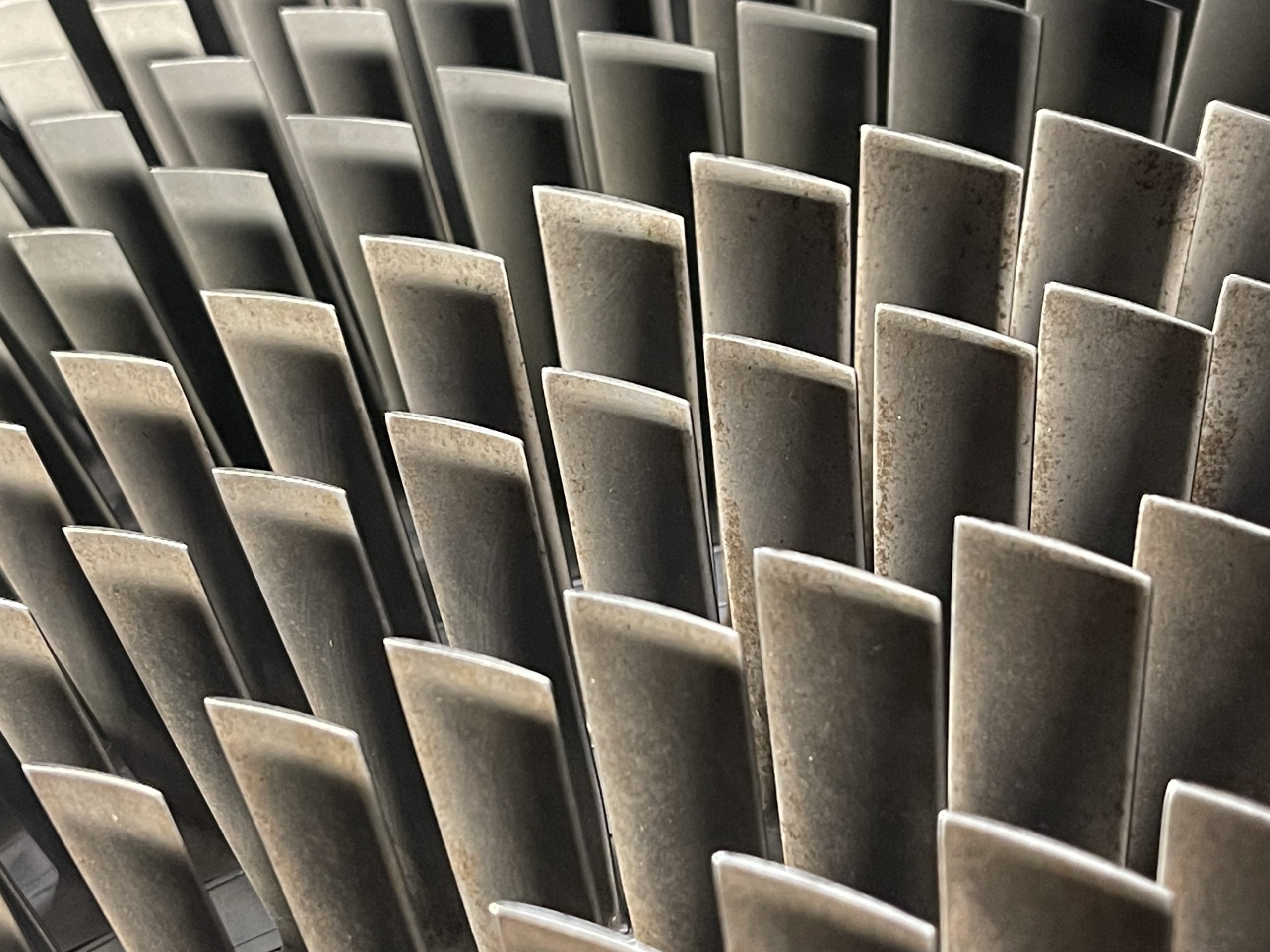
The Tuesday for me was mostly seeing how the camp worked along with a brief chat with the Camp Comm. I saw a talk with Serco where they show us various gliders and engines. I liked the engines, they were cutaway versions so I could see inside. I knew a fair bit of what was going on so I didn’t pay a huge amount of attention to the talk although I did chat with the engineer after the cadets and had some parts of the turbines explained.
RR Avon Compressor Blades
Inside this hanger were loads of gliders and it looked as though they were the original stock from my days in the corps so I looked up my gliding log on this site. I was trying to spot an airframe that I had flown in and while walking along the line of “those yet to be maintained” I spotted one.
ZE585
From this communication you can see that I’ve flown in 585 three times for around 28 minutes total. Not bad really. I do keep checking this site whenever I see an aircraft type that I know I’ve been in to see if it’s one of “mine”. Once outside we had a talk from a current glider pilot who also flew Tornados and he showed us around the two Tornados and the Tucano that were sitting on the pan.
Panavia Tornado GR4, RAF Syerston
I prefer the GR type of Tornado rather than the F type but I do have an image of the F type which is a rare one because it’s an F2 but fitted with F3 type engines and so the rear of the plane looks super stupid. But, I guess it worked. Lunch was provided by a field kitchen, and a fantastic job they did too, I was super impressed with the whole set up. In the afternoon I talked to people about PTT and how I can deliver that in my unit.
Wednesday was my final day at the camp, only here for two days if you remember and a chance to chat to people about PTT and also help with the car marshalling as parents were dropping cadets off in the base. It was nice to be involved and chat to new people. The main event for the camp was the Wednesday afternoon where a private airshow was organised and the bigwigs were invited to see what we do. There was an Air Marshall, the ACO Commandant and others. I just hung around with the few people I had go to know while my head slowly burned in the cloudy weather – we can’t wear lids on the airfield and we have to wear uniform so we can’t wear a baseball cap and I forgot my sunscreen.
On the ground was an Apache from Wattisham and a Juno from Shawbury. It was the actual Juno that I had flown in two years ago which was pretty cool. The flying display consisted of the Red Arrows, the Chinook [which also landed], a Spitfire, a Hurricane, the RAF Falcons, and finally the Typhoon.
Red Arrows – Head to Head
I had wondered whether to use my camera a lot and possibly concentrate too much on getting the perfect picture or do I just watch and absorb the atmosphere. I chose to just take the odd picture here and there on my phone. It was a really chilled out atmosphere and a good chance to chat to plenty of people. The Red Arrows performed their “rolling display” because the cloud cover was pretty low. The BBMF aircraft were impressive for their age and the Chinook was very – how the hell do you make it do that? I really wanted to see the Typhoon because – NOISE. I though even the nine jets of the Reds were quiet. Maybe it’s growing up under a flightpath that means not a lot bothers me.
Red Arrows, RAF Syerston
I was on marshalling duties when the Typhoon display took place. So I was an extra 800m away from the display centre and, while slightly disappointed, I still had a good view. I was basically in charge of keeping the parents calm and in the car park as the Typhoon display was delayed slightly by technical issues. When this thing did arrive the noise made me very happy as the first minute or two is at 100 power and full reheat. You know it’s loud when you can’t talk to the person next to you. It was brilliant and well worth driving through the bloody Dartford tunnel to see. I had a really good time at Syerston and made some good contacts. I’m looking forward to returning next year.
Hmmm, this is communication number 1939. So, in keeping with tradition I write a few things that happened in that year, I’m going to avoid the obvious:
30,000 killed in earthquake in Chile.
Borley Rectory is destroyed by fire.
Lina Medina gave birth aged FIVE, I mean, WTF?
A passenger air service starts between USA and UK.
I spent a few hours yesterday gathering resources to start the landscaping project on my base area in the Caves and Cliffs part one section of my world. I expect to move to a new base area once the next part of the update is released.
Map Of The Land
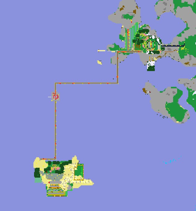
In the above image you can see railways over the sea connecting the main components of the base. Sitting in a minecart allows me to eat and get my inventory sorted while also travelling from one place to another. I am going to keep the railways but I wanted to make it look a little prettier. So, I decided to claim back some land and build an artificial island.
Obviously Man-Made
The above picture shows the start of the landscaping works. My first thought was to try and make it look natural but I’m actually now keen to make it obviously man-made. Let’s see what I can be bothered to do. It turns out I’ve also made a secret harbour area and so I need to add in railways to that somehow. The pond in the middle is going to be for the axolotls I gather. I also need to light up quite a bit of the work so to avoid mobs spawning. I don’t want all of it to look the same so I have some other ideas for joining to New Holland. Look out for a walk around video on my YouTube channel at some point.
This is communication number 1929 and so here are some things that happened in that year:
Agnes Gonxha Bojaxhiu moves to India. This woman is horrible.
I play a lot of Minecraft. I’ve been into it since the start of the first pandemic lockdown when my kids talked a lot about it and I decided it’d be nice to know what they are talking about. So I gave it a go. I have loved it every since. I mean, I made a YouTube series on my megabuild in one of our worlds.
It was an interesting experience doing the recordings once the build was complete. I had to learn how to play the game, or at least wander around, while also talking about what I have done and I found that quite tricky at first and so there were plenty of recordings that I deleted for quality purposes. I am also not going to edit the videos once recorded because that’s a level of caring I don’t have.
For a long time I have used some software t create maps of my world. I know this is cheating to a certain extent but I have decided that it’s ok to do somethings but not others. I think it’s ok to have a map and I think it’s ok to have coordinates turned on. Other than that I don’t employ any other “cheats”. I have played in some worlds with teleporting and keep inventory turned on but to be quite frank that makes it too easy. There should be an element of death and destruction within the game. The random things are what make it interesting for me. So, I don’t really play in creating mode, in fact I’ve only ever been in creative mode once, and I don’t have many “cheats” turned on. Everything I have done is in survival mode, because it’s more interesting to me.
Map Of The Land
The above map shows the area of my current base. Once the Caves And Cliffs Part One update was released I went a long way in the nether and popped out wherever it was in the overworld. The aim was to generated new areas of the world using the latest version of Minecraft. I suspect that I’ll do this again once the Part 2 update comes out and start a new-new base there.
Things to note in the map of my world are the mob-spawner just SE of the centre of the map along with an island, called New Holland, just SW of the spawner. The island is around 70% man-made in terms of area and houses my slave villagers and farm animals. There are two iron-golems there to protect the villagers which is nice I guess. It is my trading area. From the villagers I have easy access to mending and silk touch enchantments for tools. Over the next while I think I need to look more into potions and learn how they work.
Just left of centre in the map is my portal to the nether where I popped out originally when finding a new area for the latest update. There are three railways that connect this hub with the island, the spawner and my crop farm and storage area. Just NE of centre is my crop farm – currently wheat and potatoes – along with a subterranean storage area and my bed on top of a hill nearby. I’ll see if I can get some screenshots or do a video walk around of this new base area. I should probably do a video of the old base area in this world although I think I wrote about it here.
For information, the mapping software I use is called bedrock-viz for Minecraft Bedrock Visualiser. It works on the server map files and turns them into a webpage that works similar to google maps. So, if you are running your Minecraft world on a PC and you know where the database files are and you are comfortable taking copies of those then you can probably use the software. I also FTP the files to a webspace so I can see the map on a laptop screen while I’m playing, it’s a little small on my phone. I like it and I find it really helpful just for getting around the place. It’s just enough of a help that it’s worth it and not a silly amount of cheating that I think it’s ok to use. To give you an idea of what it does here is what it looks like at level 13 under my base:
Level 13 Overworld
In the real version of the map you are able to zoom in and hover over blocks to see the coordinates so that’s really helpful. In the picture above you can see water and bubble columns – blue and light blue – along with geodes. The yellow bits are gold and the dull yellow is iron. Bright blue is diamond and red is redstone, green squares are emeralds but once you’ve got a trading farm going with villagers who cares about mining for emeralds?
Communication number 1924 and here’s a selection of stuff that happened then:
A radio time signal is broadcast for the first time.
An explosion in a mine in West Virginia kills 119.
I’ve been playing around with a few things in X-Plane. I’ve tried direct flight routes using the in-flight computer along with saving flights and then recording the replays from “interesting” angles. My round the world trip started at RAF Valley, I’ll try and find a date if I can. Originally I was going to fly the coastline of Great Britain or maybe even the UK but I ended up turning right at Jersey and have been heading around the coast of Europe and then Africa. I’m currently in Namibia but struggling to find airstrips along the coast so I’m inland for a little while.
Ondangwa to Grootfontein in Namibia. Part of the #roundtheworldtrippic.twitter.com/X3NptqHwC3
I’m trying to tweet each journey with a screenshot just for posterity. My hashtag isn’t unique and so when I try to look back I’m going to get photographs of lots of people who are going around the world for real. I guess one aim of this is to see other places and see what the world looks like. Even if this is virtual at the moment maybe one day I’ll find somewhere cool to live when I retire!
Here’s a video of me landing somewhere. I recorded the flight and then managed to replay it while moving the camera around [not a great landing]:
This next video is me flying from Ruacana to Ondangwa in Namibia. I think I start the flight halfway through and then go through different views so you can see the sort of thing I look at while flying [another not great landing]:
This is communication number 1908 and so here are a few things that happened in that year [AD]:
An opera house fire in Pennsylvania kills 170.
The UK acquired the rights to the first major oil discovery in the middle east.
The model T is launched by Ford – who by the way was a fucking massive anti-Semite.
This distance is 40,000km. I think that’s why it was chosen by Polyphony to be the last achievement for distance in Gran Turismo Sport. I completed this yesterday after competing in some online races around Interlagos and then twatting the 787B around Special Stage X for four laps which was remarkably boring. I guess I should try and get the other achievements completed but I can’t be bothered to take that many photographs within the game or create that many liveries, I’ll look later and see how many that entails, if it’s one hundred then I guess I could manage it but any more will be met with a resounding “fuck that shit”.
Final [not online] GT Sport Achievement
It’s fitting that this is communication 1900 and it’s about Gran Turismo, a game I have played since its initial release back in the last millennium. It is a game I have enjoyed and still do. I am, however, concerned that the next level of controller will be produced by Fanatec and having looked at their equipment I am shocked at how expensive it is!!
Here’re some of the vaguely interesting things that happened in the year 1900:
Miners in Austria go on strike looking for better working conditions [amazing we still have issues with working conditions].
The legal workday in France is limited to just 11 hours – for women and children.
The Italian King is assassinated.
Max Planck discovers the law of black-body radiation.
As part of my round the world trip in X-Plane I landed at Omboue Hospital in Gabon. It’s such a quiet airfield that X-Plane has nothing there. Not sure where my next stop will be, I’m considering flying over the top of the DRC as, you know, it’s the DRC and not a healthy place.
This is my current base in this latest world. I’ve written about things recently but this is a whole new era of my Minecraft skills. I have a simple base at the moment, I have a villager breeding area as I try to get the mending enchantment and I have a kelp XP farm. Things are going OK at the moment. The island in the bottom is mostly reclaimed and so I’ll be calling it New Holland.
I’ve got railways joining these places over the sea. This land is in a new chunk since the caves and cliffs update part one and therefore there are geodes and glowing squid all over the place. I’m not sure how to make a proper base yet, but part of me wants to build up a massive volcano and go completely Bond-villain.
My current flight sim plans are wandering around the Earth from airport to airport and just enjoying the views. I’m currently heading down the west coast of Africa and have recently started recording my journey on Twitter. I don’t use Twitter a huge amount at the moment because ultimately no-one cares what I think and I have friends whom I can moan to about things.
Side image shows mountains of the Campo Ma'an Reserve, Cameroon. Then, Bata approach and full stop at Bata, Equatorial Guinea. #roundtheworldtrippic.twitter.com/uy35VUtKTr
Having just clicked on the hashtag I can see that there are many people using the same hashtag but in reality. They are travelling around the world. Well, given the current pandemic, I am not. Also, I don’t have the money and I have other responsibilities at the moment so I don’t think I can. My next trip is to Scotland in February.
X-Plane Control Panel – iOS
This is a screen capture of the X-Plane Control Panel on my iPhone. It looks at the information in X-Plane on the PC and gives me information about my flight. The bottom display is my glideslope approach to an airport, the middle display is a kind of map with weather display and the top is my PFD. I’m quite impressed with the extra information I get and I’ve been using the glideslope when my approach is through clouds. None of those landings have been successful though and I generally fly those routes again or it seems like I’m cheating. One thing that does happen though is once the iPhone is connected it changes the weather from real-world to whatever the settings are on the phone and that’s a frustration, I will look into this to see if I can correct it.
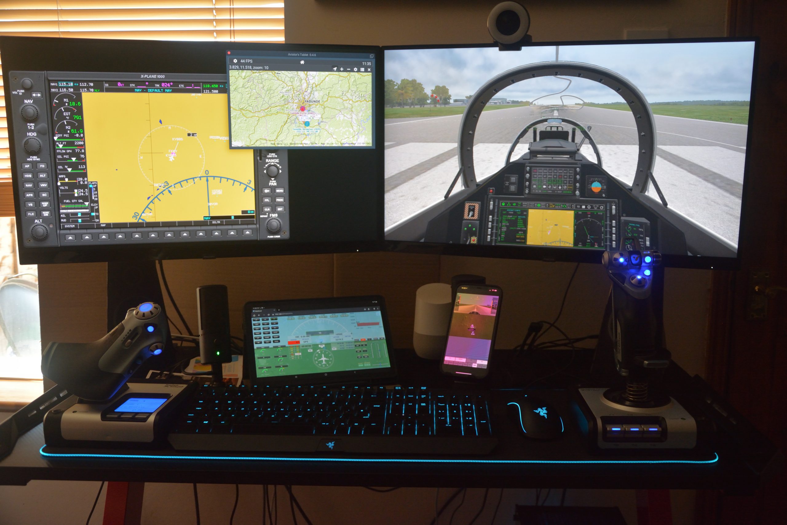
This is the system I use to play on the flight simulator. I really enjoy my time flying around the world virtually and trying to split the journey up into twenty minute flights.
X-Plane Set Up
The stuff I have here is a HOTAS system from Logitech, two PC screens, keyboard and mouse from Razer along with two external displays. The Samsung tablet runs some software giving me a PFD and the information involved there. My phone runs some software which is similar to the tablet PFD but also includes glideslope information and forward terrain. In the picture below you can see my chair, which I absolutely love. It’s a lovely chair.
My Favourite Chair
It was quite hard to get the camera to take a reasonable photograph of the system because I have a polarising filter on the lens and as the displays are also polarised, but in different directions, it means that I couldn’t really get the best direction of the polarisation. But I did ok. Here is what it looks like at its worst.


![Final [not online] GT Sport Achievement](https://fooyah.net/wp-content/uploads/2021/07/E7FgeSZXIAoPXYd.jpg)