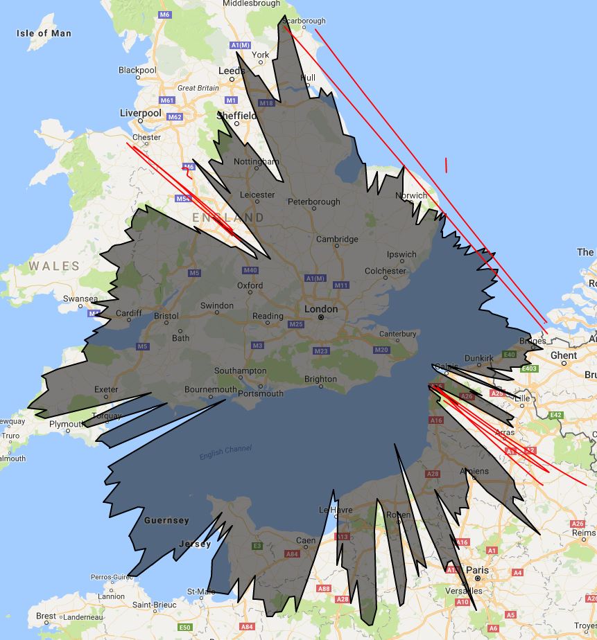
With reference to the previous communication I can update the main blockages on the ADS-B splat. I wrote about this before here.
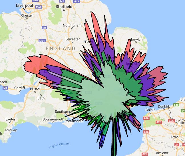
Blocked Areas Labelled
The blocked area labelled 1 covers the North Downs. This natural boundary lurks to the NE of me and I can’t do a great deal about it.
The blockage labelled 2 is, I believe, down to the aerial being inside my loft and the terrace houses of my block extending in that direction. I wrote about that here. The only way to improve this range would be to get the aerial placed above the roof of my house, which is not a job I am going to undertake. I may, however, consider getting someone else to do it.
These communications contain many items concerning the virtual radar system that lives in my loft and you can see a selection here. A short while ago I decided to buy an pre-amp and filter for my system to improve the range and number of aircraft being received. So, this communication now requires a large number of pictures to give you an idea of what this means.
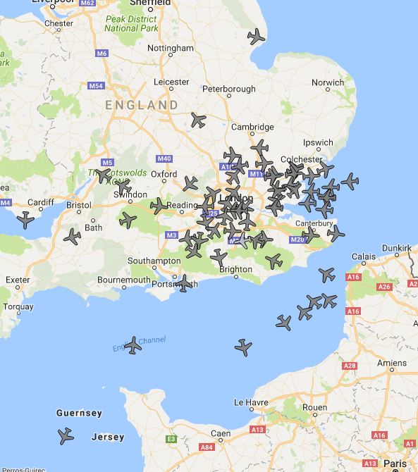
Pre Filter Range 1
In the above picture you can see that there are around 20 aircraft and the black area [the range of the receiver] doesn’t quite reach Norwich, Portsmouth, Bristol or Calais. There is the NW-SE block as described before.
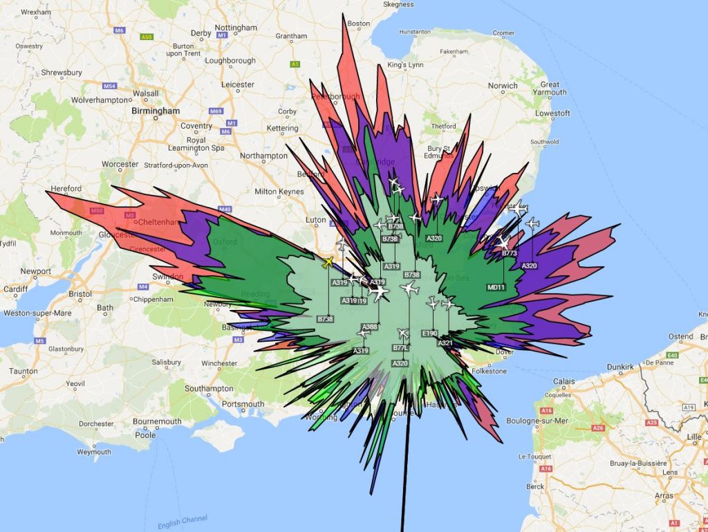
Coloured Splat
This coloured splat gives pretty much the same information but uses colours for the ranges of aircraft at different altitudes.
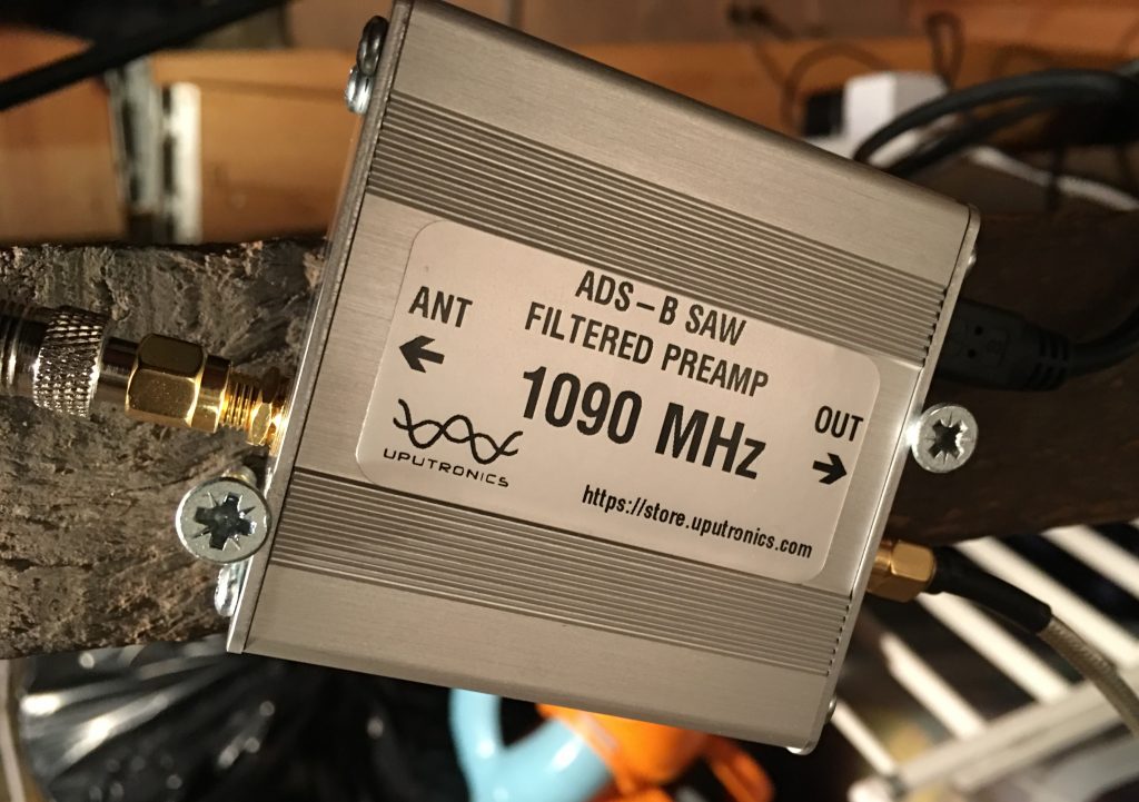
I bought a filter which only allows signals close to the 1090MHz requirement through to the USB stick I bought. It also acts as a pre-amp so there is an overall 14 dB gain.
Pre-Amp and Filter held securely in place
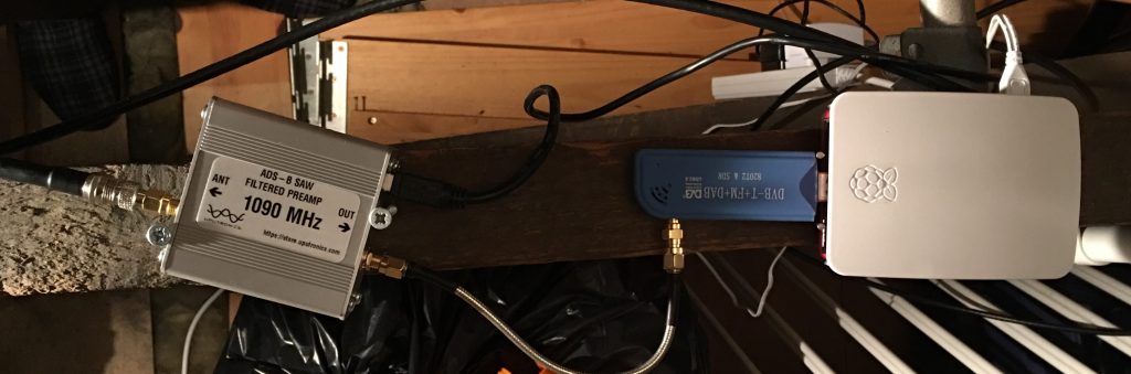
Here is the whole Virtual Radar system living in the loft:
Pre-Amp Filter, USB, Raspberry Pi
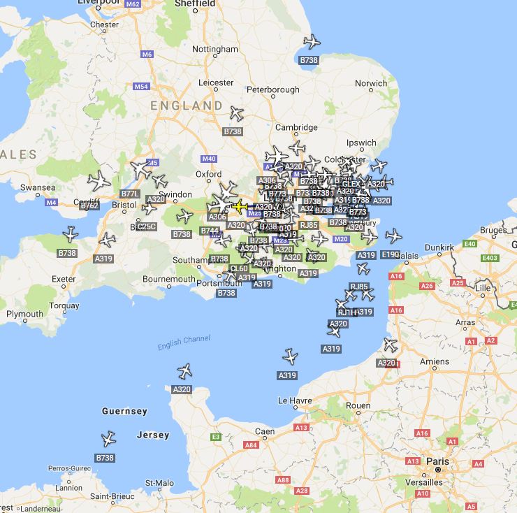
Once this kit was turned on I looked at the DUMP1090 output from the Raspberry Pi and pretty much shat myself at the number of aricraft shown:
Initial DUMP1090 view
When this view is compared to the twenty or so aircraft that I had before you can see an immense improvement in the receivers ability.
Virtual Radar Server View
Virtual Radar Server is a program I use on the RPi for a more detailed view, there are quite a few customisations you can create also. It is the software that will create the splat over time, keeping track of the aircraft and their position.
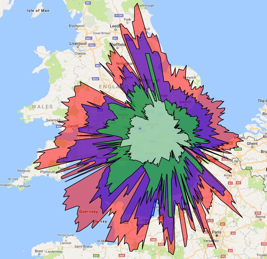
Holy Splat!
The distances have increased as has the overall coverage. I now track around 100 aircraft at a time. For a small sum of money the overall increase in detail has been terrific. I can now reach over northern France, over Wales and a lot of the channel to the SW.
I am aware that in some places on the internet caturday is a thing. I do not care for this. Nor do I care for cute dog picture stuff. It’s quite boring, especially when associated with a meme [a word now misused]. There is a smaller, some might say darker, part of the internet where comparing the range of an ADS-B receiver is a thing. These are called “splats” and so here is my Splaturday picture.
There are other communications cover this sort of thing here and here.
What’s the point in having an ADS-B receiver if you aren’t going to use it when you are out of your house? So, I managed to set up some wizardry on parts of my home network and now I can see the display from outside the confines of my wireless network. I’ve done some port forwarding and other lovely stuff which is easy enough if you are adept at googling, which I am.
Family thinks I’m a god because I can use regedit to fix a computer. But I’m really quite good at JFGI.
So, I now have a Virtual Radar Service for the area around my house that I can log in to from anywhere in the world. I did have to set up a Dynamic Domain Name Service for my modem as I am not lucky enough to have a fixed IP from my broadband supplier. My router even informs the DDNS service what its new IP is whenever it restarts and because this just seems to work it makes me happy.
I did have some minor issues with the radar service as it uses Google Maps to provide a nice background and because I was using this outside of my home network I needed an API key to make this work. That was reasonably easy to set up but then it turns out that Google recommend you secure the key to a particular site so that other people can’t use your key and steal your Maps data, which would then mean Google would charge me.
It took a little while to get the formatting of this securing correct but I think I finally managed it. I guess I’ll soon find out if Google send me a massive Google Maps API bill soon!
So, I can log in to my radar server from anywhere and view it on a desktop or mobile device. That way I can see what my home system sees. It doesn’t catch all planes because some won’t be broadcasting position, see the MLAT communication. Below is a picture of a browser with my radar server running.
Virtual Radar Server
If you want access I can allow it to you. Just let me know and I’ll arrange a login and password and also give you the URL.
I’m interested in aircraft. I don’t know why it started but it’s pretty much always been there. I grew up near Stansted airport and I can remember seeing the Space Shuttle visit in the early 80s, I saw the 747 and Shuttle circle around from the primary school playing field. When I studied art at secondary school every picture of mine contained an aircraft much to my teacher’s annoyance.
Nowadays it’s easy to see aircraft on the web. I have the planefinder app installed on my phone and often tweet when I spot an A380. I only really tweet the A380 as it’s massive and extremely beautiful.
Spotted! 9M-MNF (MH3) using @planefinderhttps://t.co/eOkZ5aOMBepic.twitter.com/3IQx0fcfaE
My aircraft thing also meant I travelled to Stansted to see Air Force One take off a few months ago.
28000
I wanted to find a way to see what military aircraft are doing in the skies and I found a website called 360Radar who have this information. The site isn’t open to public yet and I emailed to see if I could get a test account. They said yes.
I like the site. I like the filters and information that I can see. This site relies on people sharing their MLAT data with them and they will offer a free account if you share data. They have a great comprehensive guide to setting up a system that is currently here. I ordered a small aerial and it arrived today. Within about thirty minutes of getting to the computer I was running the data server and sending information to the network.
I have a USB aerial picking up 1090MHz signals from aircraft. I then have a small program running to collate that data and form it into useful data.
Screen Grab of ADS-B Signals
You can see that I am picking up an aircraft over Cherbourg which I think is quite impressive. All of my aircraft are south of my position because my aerial is placed in a south window. I will look into moving the aerial to a more central, higher position in the house so that I can pick up aircraft all over!
Here’s another screen grab of the output from my aerial.
Another ADS-B Map
How it works
Many aircraft broadcast position information on 1090 MHz. This information comes from the aircraft’s navigation system but does not require the pilot to be involved in the operation of the system. The position of the aircraft is determined by GPS. This output information is called Automatic Dependent Surveillance Broadcast. My little aerial picks this up and reads it. My computer then sends this information to a website which aggregates the information.
For aircraft that don’t output the ADS-B signal their position and direction can be known using multilateration [MLAT]. This involves two or more base stations and measuring the time difference between each station receiving a signal. It’s very clever!